EuroVelo - The Trans-European Cycle Routes
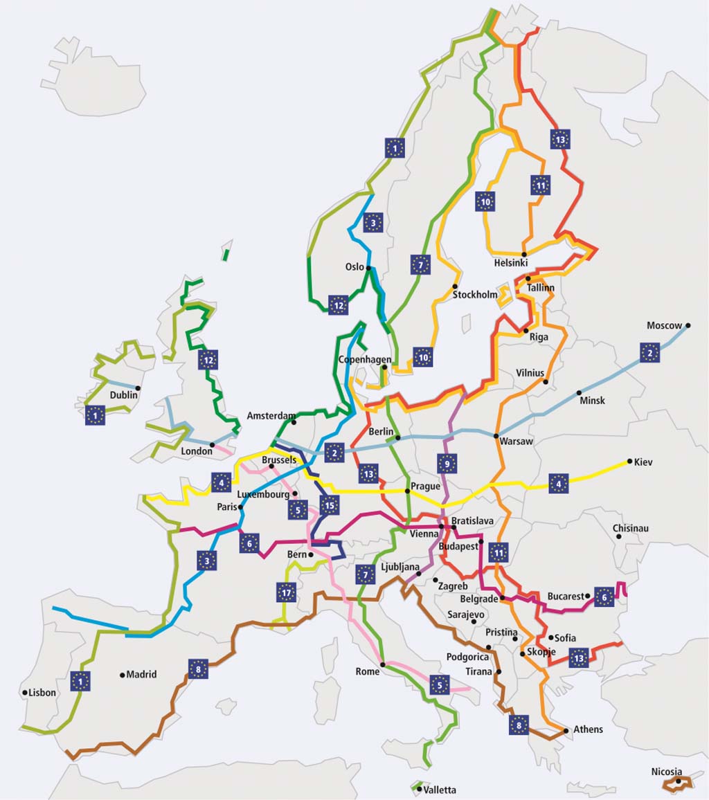
EuroVelo - map of the network
EuroVelo is a network of trans-European cycle routes.
The map (from European Cyclists' Federation)shows a total of fifteen itineraries including nine oriented North - South (labelled 1, 3, 5, 7, 9, 11, 13, 15 and 17), four oriented West - East (labelled 2, 4, 6, and 8) and two loops (labelled 10 and 12).
Note: EuroVelo 14 and 16 are the routes that does not exist (yet...) !
The page EuroVelo in Franceprovides further details of those cycleroutes which cross into the hexagon.
The current fifteen EuroVelo cycle routes
- EuroVelo 1
- Atlantic Coast Route | North Cape – Sagres 8,186 km
- EuroVelo 2
- Capitals Route | Galway – Moscow 5,500 km
- EuroVelo 3
- Pilgrims Route | Trondheim – Santiago de Compostela 5,122 km
- EuroVelo 4
- Central Europe Route | Roscoff – Kiev 4,000 km
- EuroVelo 5
- Via Romea Francigena | London – Rome and Brindisi 3,900 km
- EuroVelo 6
- Rivers Route Atlantic – Black Sea | Nantes – Constanta 4,448km
- EuroVelo 7
- Sun Route | North Cape – Malta 7,409 km
- EuroVelo 8
- Mediterranean Route | Cádiz – Athens and Cyprus 5,888 km
- EuroVelo 9
- Baltic – Adriatic | Gdansk – Pula 1,930 km
- EuroVelo 10
- Baltic Sea Cycle Route | (Hansa circuit): 7,980 km
- EuroVelo 11
- East Europe Route | North Cape – Athens 5,984 km
- EuroVelo 12
- North Sea Cycle Route | 5,932 km
- EuroVelo 13
- Iron Curtain Trail | Barents Sea – Black Sea 10,400 km
- EuroVelo 15
- Rhine Route | Andermatt – Hoek van Holland 1,320 km
- EuroVelo 17
- Rhone Cycle Route - also called ViaRhôna before it joined the network in 2016 | Swiss Valais – Port-St-Louis-du-Rhône 1,115 km or Le Grau-du-Roi and Sète 1,165 km


