EuroVelo cycle routes in France
EuroVelo cycle routes in France

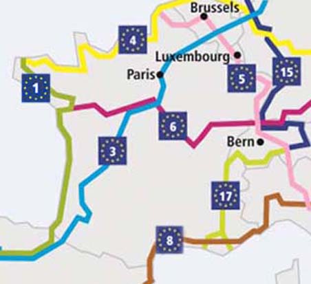
EuroVelo - map of the network in France
EuroVelo is a network of trans-European cycle routes.
In France it shows a total of eight itineraries including five oriented North - South (labelled 1, 3, 5, 15 and 17) and three oriented West - East (labelled 4, 6 and 8 ).
The current height EuroVelo cycle routes in France
- EuroVelo 1 - 1200 km in France:
-
- ■ Border with ENGLAND ▻ Roscoff (29680) - Bretagne
- ■ Border with SPAIN
- Also known as La Vélodyssée
▻ Hendaye (64700) - Pays Basque
- EuroVelo 3 - 1680 km in France:
-
- ■ Border with BELGIUM ▻ Jeumont (59460) - Nord
- ■ Border with SPAIN
- Also known as La Scandibérique
▻ Saint-Jean-Pied-de-Port (64220) - PyrĂ©nĂ©es
- EuroVelo 4 - 1200 km in France:
-
- ■ Endpoint is here in FRANCE for the EuroVelo 4 ▻ Roscoff (29680) - Bretagne
- ■ Border with BELGIUM
▻ Calais (62100) - Nord
- EuroVelo 5 - 550 km in France:
-
- ■ Border with ENGLAND ▻ Calais (62100) - Nord
- ■ Border with SWITZERLAND
▻ Saint Louis (68300) - Alsace
- EuroVelo 6 - 1300 km in France:
-
- ■ Endpoint is here in FRANCE for the EuroVelo 6 ▻ Saint-Brevin-les-Pins - VendĂ©e
- ■ Border with SWITZERLAND
▻ Huningue (68) - Alsace
- EuroVelo 8 - 700 km in France:
-
- ■ Border with SPAIN ▻ Le Boulou (66) - Roussillon
- ■ Border with ITALY
▻ Tende (06) - Alpes du Sud
- EuroVelo 15 - 190 km in France:
-
- ■ Border with SWITZERLAND ▻ Lauterbourg (67) - Alsace
- ■ Border with GERMANY
▻ - Alsace
- EuroVelo 17 - 815 km in France:
-
- ■ Border with SWITZERLAND ▻ Valleiry (74) - Alpes du Nord
- ■ Endpoint is here in FRANCE for the EuroVelo 17
- Also known as Rhone Cycle Route - called ViaRhĂ´na before it joined the network in 2016
▻ V60A: Port-St-Louis-du-RhĂ´ne 1,115 km
▻ V60B: Le Grau-du-Roi and Sète 1,165 km - Camargue - Languedoc (V60B)


